Posts

Showing posts with the label lake

Shasta Lake horror—and a glimmer of hope
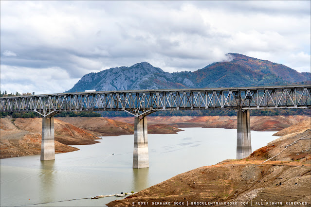
Image
On the way home from visiting my mother-in-law in the town of Mount Shasta , we stopped at Bridge Bay Resort to take some photos of Shasta Lake .  Located at an elevation of 1,067 ft. fifty miles south of Mount Shasta and ten miles north of Redding, Shasta Lake is California’s largest man-made reservoir and its third largest body of water, after Lake Tahoe and the Salton Sea. It feeds the Sacramento River watershed and hence much of the Central Valley, and water from the lake also supplies a hydroelectric powerplant at Shasta Dam. With 365 miles of shoreline it’s also a major tourist destination in the North State, especially for houseboating. At least when things are “normal,” not that the word “normal” means much anymore in a time when California seems to lurch from one climate crisis to another. On October 31, 2021, the day I took these photos, the water level was at 885 ft. (full lake elevation is 1067 ft.). That translates into a shocking 22% of capacity. To put this into c...

Europe 2017: German Alps, day 2

Image
Day 2 of our stay in the Bavarian Alps was all about the Königssee . This fjord-like lake in Berchtesgaden National Park is surrounded by mountains rising steeply to 2,700 m (8,900 ft), including the Watzmann , Germany's third highest peak. The setting is drop-dead gorgeous. St Bartholomew's Church on the Hirschau peninsula of the Königssee The easiest way to see the lake is by boat. A fleet of electric boats provide service to St Bartholomew's Church about half way up the lake and to Salet, the terminus at the far end. The trip takes about two hours, there and back. 

Lake Berryessa Glory Hole

Image
Located less than 30 miles from our house, Lake Berryessa  is the 7th largest reservoir in California . Like all lakes, its water level has risen significantly in recent months as a result of the wettest winter California has had in decades. However, unlike Lake Oroville whose dam  spillway threatened to collapse , which would have flooded downstream communities as far away as Sacramento, Lake Berryessa has been in the news this past week for something much more positive: On February 16, the lake level reached 440 ft--enough for water to flow into its spillway. Unlike traditional spillways--essentially chutes or channels allowing the controlled release of water from a dam--the Monticello Dam at Lake Berryessa has what is known as a glory hole spillway (also called morning glory or bell mouth after its shape). At the height of the drought, this spillway looked like a concrete donut on a tongue of land sticking into the lake ( see photo here ). Now it brings to mind a ma...